
The two historic bridges at Clifton are (just about) within lockdown walking distance for me, and another visit had been on my radar for a while. Both the aqueduct and viaduct are impressive structures, both are Grade II listed, and both ceased to undertake their intended purpose well before my own lifetime.
A winter or early spring visit was on the cards, for two reasons. Firstly, as you might recall if you watched my Salford Trail video, my previous visit to this part of Salford had the sparkle removed by my dislike for giant hogweed. Secondly, the steep sides of the Irwell valley make it much easier to get a good view of the two bridges in winter without the excess foliage. This is particularly so for the aqueduct, which as the more diminutive of the two structures sits far lower in the valley. On 20th March 2021, I headed over to take a few snaps.
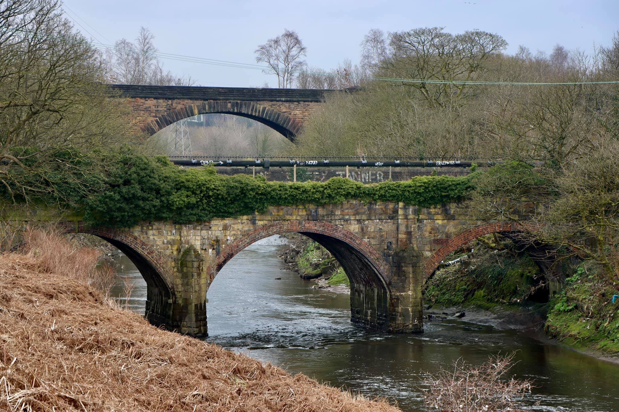
Clifton Aqueduct (foreground) and the main span of the Clifton Viaduct (background).
The Clifton Aqueduct
Engineers Charles Roberts and John Nightingale built the Clifton Aqueduct in 1796 to carry the Manchester, Bolton, and Bury Canal over the River Irwell. A second aqueduct at Prestolee (built in 1793) carried the canal back over the meandering river further upstream.
The Canal was officially abandoned in 1961 and the aqueduct is currently without water, although it remains a popular crossing for walkers and cyclists, being adjacent to Prestwich Forest Park and the starting point for the Outwood Trail to Radcliffe. You can read more about efforts to maintain and restore the canal on the Manchester, Bolton, and Bury Canal Society website.

The Clifton Aqueduct
Clifton Viaduct
The aforementioned Outwood Trail follows the route of the Manchester, Bury, and Rossendale Railway (MBRR) from Clifton to Radcliffe. By the time the line (and the magnificent viaduct) had been completed in 1846, the MBRR had merged with the pithily-named Burnley, Accrington, and Colne Extension Railway to form the East Lancashire Railway (ELR). The ELR is both mercifully less of a tongue-twister and also still a known moniker in 2021, in the shape of the heritage railway which covers part of the original route from Bury to Rawtenstall. The original East Lancashire Railway lasted until 1859 when it was subsumed into the much larger Lancashire and Yorkshire Railway.
The 13 arches of the Clifton Viaduct became defunct along with the rest of the line from Clifton Junction to Bury in 1966. Unlike the aqueduct which remains a well-used walking route, the viaduct is fenced off and notionally out-of-bounds. The fence - on the Bury side at least - had been clearly breached as at my visit, but I thought better than to explore further. Others would no doubt be more foolish or adventurous - delete as you prefer.

Clifton Viaduct central span over the River Irwell, taken from the Clifton Aqueduct
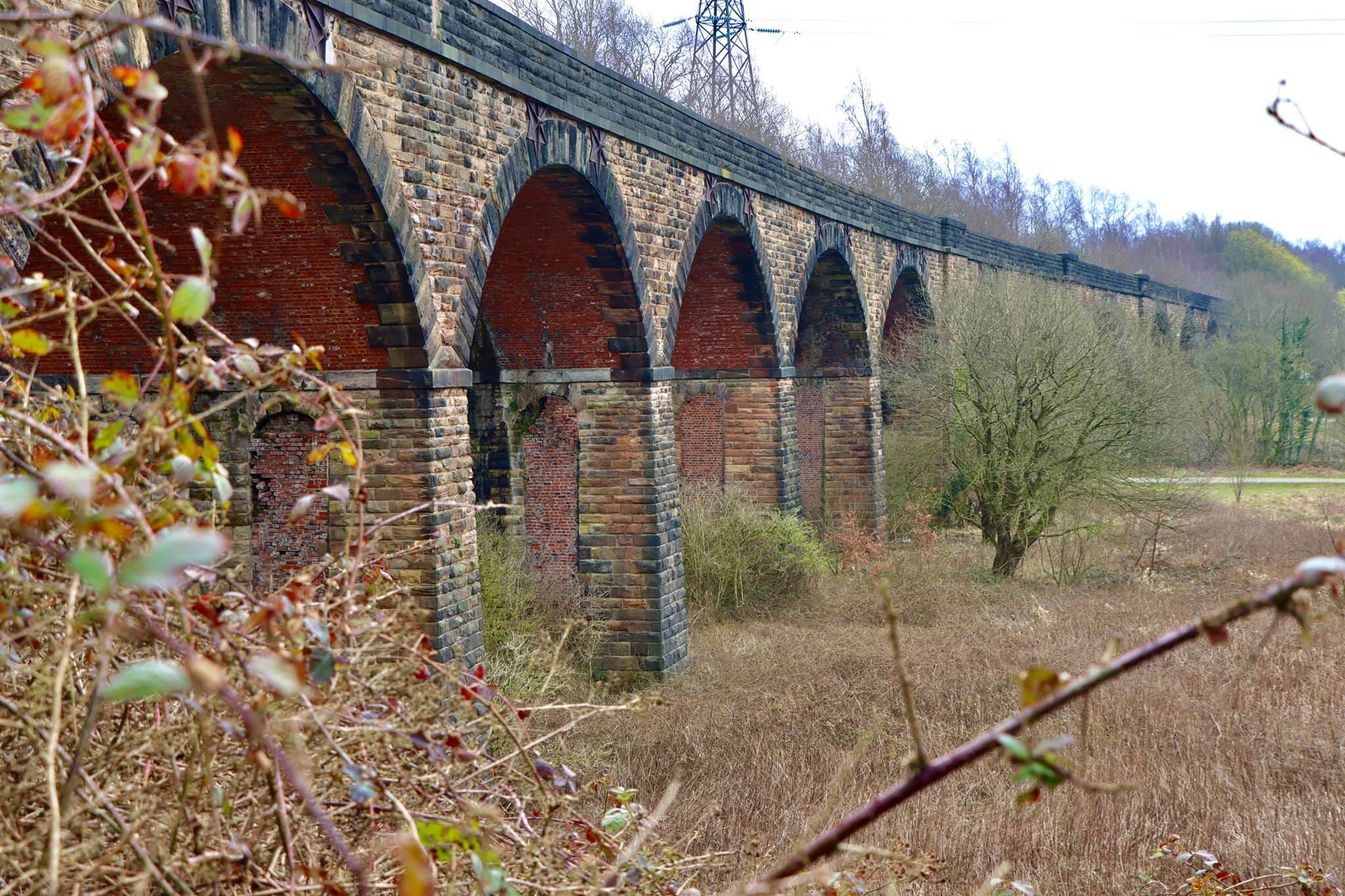
The 13 arches of the Clifton Viaduct, looking south from the Prestwich side
Ringley Old Bridge
Despite being over 220 years old, the Clifton Aqueduct is not the oldest bridge over this stretch of the River Irwell. That honour goes to Ringley Old Bridge a little further upstream. Ringley Old Bridge is a Grade II* listed building and was built in 1677 to connect the villages of Ringley and Stoneclough - making it just six years shy of 350 years old.

Ringley Old Bridge